Warning: call_user_func_array() expects parameter 1 to be a valid callback, class 'collapsArch' does not have a method 'enqueue_scripts' in C:\inetpub\vhosts\globitrotter.com\httpdocs\blog\wp-includes\class-wp-hook.php on line 307

Queen Charlotte Track

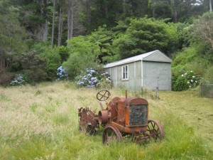
On Christmas Eve we caught the ferry over to the South Island from Wellington. The ferry brings you to Picton were we had decided to stay over the holiday. On Christmas Day everything was closed so we could not expect to do much that day. Only thing to do was to have a lazy day and cook some nice food and drink wine. This we did together with Jasmine from Austria who we met first at Tongariro and then by chance again on the ferry.

After our Christmas celebrations it was time to organize our next outing which was going to be the Queen Charlotte Track. The track runs along a ridge in the Marlborough Sounds in the northern most part of the South Island. It is a little different since it passes a lot of private land and there are no DOC (Department of Conservation) huts, only campgrounds. If you do not want to camp there are a lots of options, hotels, B&Bs and hostels. We decided to bring our tent though.

IMG_3214_a copy

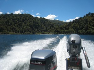
On the ferry to Ship Cove.

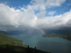
On Boxing Day we caught the afternoon ferry to the start of the track, Ship cove. From there it took us four days to reach Anakiwa from where the ferry was going to bring us back to Picton. Unfortunately the weather was not the greatest. The clouds were quite low but at least it did not rain heavily during the days but only at night. So we kept dry and happy for the entire time. Even with the low clouds it was a beautiful hike through native bush, along the water front and mostly on top of a ridge.

IMG_3248_a copy

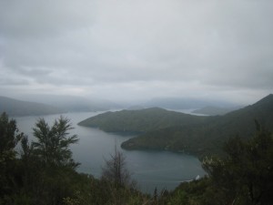
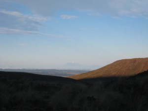
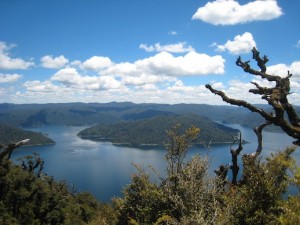
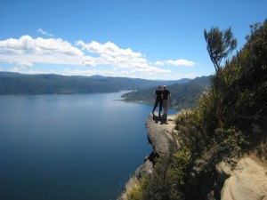
At the highest point of the track. On a clear day you are supposed to be able to see all the way to the North Island. We were not so lucky but it was still beautiful.

IMG_3233_a copy

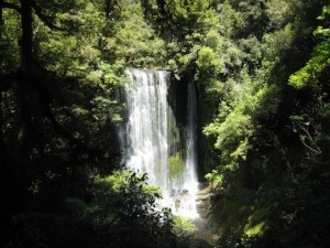
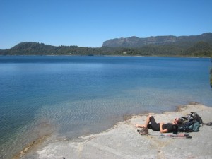
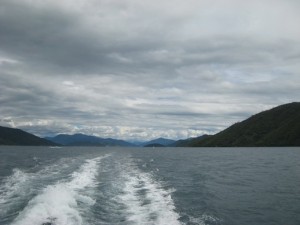
Somewhere along the track

IMG_3269 copy

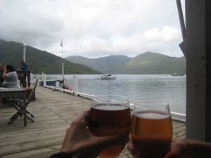
What made us even happier was the fact that next to the campgrounds day two and three there was a bar. Almost like being in the Alps you get a beer at the end of the day! Nice! Even though we had to carry our tent which made the backpacks a bit heavier it felt like a luxury hike. We could of course have left some of the food and eaten in restaurants on the way but that would be like cheating. The beer was luxury enough.

IMG_3235_a copy

Click here for more images:

Queen Charlotte Track

Tongariro Northern Circuit

You might have heard of the Tongariro Crossing, one of the most wellknown day hikes in New Zealand, which is a part of the Tongariro Northern Circuit. The track is about 45 km and we decided to do it in 3 days. The first day was very short, just a few hours to the hut and basically no elevation gain or loss. When we started the weather was a bit unstable but as we woke up the second day the sky was blue.

IMG_3073 copy

The view from the first hut with Mt Taranaki at the horizon.

From the track we could see the snow capped Mt Taranaki at the west coast. The second day started along the Tongariro Crossing which meant it was full of people. It looked like an ants trail and we were happy it was only a part of our hike that was going to be that crowded. Tourists are generally not very well equipped and on a tight time schedule. This means anything that involves an over night stay without hostels or hotels available will be relatively empty and mainly filled with locals.

IMG_3110 copy

Following the ant trail on the Center Crater.

After an hour or so hiking we found ourselves at the foot of Mt Ngaruhoe (featuring as Mt Doom in the Lord of the Rings trilogy). We had not really planned to climb the peak because we thought there would still be too much snow on the top and that it would be too much for one day. We were going to skip one hut and go to the next one which added a couple of hours to an already full day. But we had seen that the snow had melted and although it was going to be hard we could not resist the temptation.

IMG_3078_a copy

At the base of Mt Ngaruhoe

IMG_3089 copy

On the peak.

Mt Ngaruhoe is an active volcano which is an almost perfect cone. It might not look so bad from a distance but it is very difficult to climb with loose rocks and steep slopes. It did not make it easier with the big backpacks but within 1.5 hours we were on the top and could enjoy the views while having lunch. There are quite a lot of people climbing the peak which is dangerous because of falling rocks. The day before we hiked one guy had to be pick up with helicopter after being hit by a rock. We made it though without injuries and could make our way towards the hut.

IMG_3118 copy

Emerald Lakes which we passed on our second day.

Finally around 6 o’clock in the evening we made it to our hut which was newly opened and had great views of the Mt Ngaruhoe. We just barely made it through dinner before we fell a sleep exhausted after another great hiking day.

IMG_3133_a copy

The view of Mt Ruapehu which we saw a lot of the last day. The trail ran between Mt Ruapehu and Mt Ngaruhoe making it a very beautiful part of the track.

The last day was fairly short and easy with not much elevation gain. We made it back in time to have afternoon tea in the Chateau at the end of the track with Anna and Basti that we had met along the way. A very nice ending of a beautiful hike in volcanic surroundings which are not very common in New Zealand. Usually a great part of the hikes are through forest but this one only has about 30 min of forest in three days.

IMG_3161_a copy

Afternoon tea with a view of Mt Ngaruhoe. What an excellent end of a great hike.

Click the image below and you can see more photos from the hike.

Tongariro Northern Circuit

Lake Waikaremoana – an unexpected journey

The Lake Waikaremoana track is actually one of the New Zealand so called Great Walks but not very well known. Hardly any tourists know about it, including us until recently. We were told about this track by an Israeli tourist we met in Holly Hut on our Taranaki adventure. It sounded nice and after doing some research we booked huts and were on our way.

IMG_3014_a copy

View over Lake Waikaremoana.

We spent one night before the hike at the campground by the lake that also operates the water taxi you need to take to the start and from the finish of the track. It was nice to get a boat ride on the lake but the down side with the water taxi is that you have to be somewhere at a certain time which is difficult when you have not done the track before. Afraid of not having enough time you instead end up waiting for a long time. We had nice weather though so it was not so bad lingering at the end of the track. We were also in the good company of Warren who did the same hike as us. He was nice enough to then invite us to his home in Palmerston North were we later spent a few nice days. We particularly liked to try Pavlova, the national New Zealand dessert, and Shepherd’s Pie. 🙂

IMG_3006_a copy

On the ridge about halfways to Panekiri Hut.

The first day we hiked up and along a ridge line to Panekiri Hut. It was a short walk, although including some elevation gain, and we were at the hut early in the afternoon. At the hut we met a school group from Orewa and ended up playing games with them a few hours. It made the time pass a bit quicker and we learned some new games we will probably never play again or remember for that matter. 🙂 The views from the top of the ridge were great and different from what we were going to see the coming two days.

Day two the trail took us off the ridge and down to the lake. The trail more or less then followed the side of the lake until the finish of the track. We made a small side trip to a waterfall which was actually one of the nicer ones we have seen so far. Even with this side trip we had some time to relax by the lake for a while. Our hut was hidden behind a small hill which at the end of the day felt like a mountain. Overall there had been more ups and downs than we had expected on this day. It felt good to be at the hut and be able to wash (we did not swim, it was way too cold for that) a bit in the lake. Warren was already there to welcome us and the three of us were the only ones in the hut that night.

IMG_3033_a copy

The waterfall

IMG_3040_a copy

Relaxing

The last day we started early to make sure we would be at the pick up point in time. It was an easy tramp to the end of the trail. We did pass one hill but it was not very steep and actually easier than we had expected.

IMG_3047_a copy

Leaving the second hut.

Even though we took our time and made several breaks along the way we were still one and a half hours too early. Overall, it was not a very strenuous hike but our feet were stilltired and we were happy to be on our way to Taupo and a shower.

IMG_3055 copy

Leaving the pick up point at the end of the track.

Want to see more photos? Click on the image:

Lake Waikaremoana

Hiking the high circuit around Mt Taranaki

Around Mt Taranaki or Mt Egmond there are many trails. One trail is the round the mountain high circuit that in 4 days takes you around this cone shaped volcano. In the summer the snow melts enough to make it a fairly easy but of course strenuous hike to the top. Now it is still spring and the summit is snow capped and climbing it requires winter equipment and appropriate experience. The snow makes the mountain more photogenic but it would have been nice to be able to climb it.

The first day was an easy hike from the visitor center in North Egmont to Holly Hut. It took us less than 3 hours and we had lots of time to enjoy the evening sun on the terrace. The huts are fairly basic with bunk beds, tables, benches for cooking and a fire place. Water is available and there are pit toilets. There were 5 of us for the 32 beds in Holly hut so not very crowded. It got a little cold at night but otherwise comfortable.

Day two was cloudy and a very light drizzle was in the air in the morning. The trail was mostly in the forest so it was not too bad that the weather was not very good. This day was probably the most adventurous of the four. We had to cross a number of streams, climb ladders and muddy, slippery slopes. The streams were more or less easy to cross. We did not get wet but occasionally had to search for the best spot to cross. It was quite strenuous with a big backpack to jump rocks and climb slopes but also made it a bit interesting. As we were taking a lunch break in the Kahui Hut the sun came out and we ended up staying an extra hour to just enjoy the weather before heading into the forest again. We made it to the next hut by 16.30. After a little while it started to rain heavily but we were already inside in front of the fire. Good timing. There were others that were not as lucky. When it was almost dark two women arrived at the hut. They had been walking for almost 9 hours, the last two at least in pouring rain. They had no chance to dry their clothes until it was time to leave again next morning.

As we looked out of the windows the third day we saw that the hut actually had a great view of the summit. Something we had not seen in the bad weather the day before. Just a few minutes from the hut there was a long ladder that we had to climb down to reach a stream. It had a bit too much water and it was not obvious where to cross it. Andy was able to jump from rock to rock to the other side but I realized I would not have made it the same way he did. I decided to take my shoes off and walk through it. The water was freezing but I stayed dry which was the main thing. After that the trail took us up above the tree line. The weather was prefect with a blue sky and the views spectacular. We could even see all the way to the south island. The plan was that this was going to be a short day with only about 8 km hiking. The hut we were supposed to go to, Dive Lake hut, was situated next to a small lake in the forest. But since the weather was so good and we were already on higher altitude we decided to continue to the next hut, Waingongoro hut. It took us totally about 7 hours of hiking to reach the next hut. About one hour before we reached the hut we passed by another visitor center and café where we got a well deserved soda and scones.

The last part back to the car did not take more than about 3 hours. The weather was generally fine with some clouds and occasionally strong winds. This side of the mountain is more popular and has a lot more trails. Many do day hikes or overnight hikes. This means that the trails are also more looked after and easier. Partly we were even walking on service roads. When we came back to the car we cleaned up a little and went for coffee in the visitor center. At this point we were quite tired after hiking 55 km in four days, 19 hours hiking time. We were longing for a shower and dinner at a restaurant.

Click on the image to view more photos from the hike

Mt Taranaki – New Zealand

And for the stat nerds:

Coromandel

Coromandel is a peninsula just east of Auckland. In the center of the peninsula there is a mountain range that has a few nice trails. We spent one day hiking the Pinnacle which was a very nice trail. The last part up to the top included some climbing which always makes us happy. The views were also excellent.

Otherwise Coromandel is mostly known for its wonderful beaches including Hot water beach. Hot water beach is named after the thermal water surfacing at the beach. At low tide you simply dig a hole which fills with hot water and you have made yourself you own private spa. Unfortunately we do not have pictures of this because we did not want to get the camera wet. It looks quite amusing though with lots of people sitting in holes in the sand.

The weather was not very stable when we were at Coromandel but we managed to take advantage of the good moments which you can see in the images.

Click on the image to see photos from Coromandel.

Coromandel – New Zealand

Northland

In our “new” (actually quite old but therefore fairly cheap) home, the rebuilt Nissan van we rented for our stay in New Zealand, we headed north out of Auckland. The first day we did not drive far but checked in at a campground in Orewa to settle in and find a place for everything. The campground was situated at a very pretty beach perfect for an evening stroll.

Driving along the coast we made our way up to Russell and then on to Cape Reinga. There is an abundance of nice beaches, pretty islands and green, sheep filled hills in this part of the country.

Nice farmer’s market in Matakana.

Cape Reinga

Cape Reinga

At Cape Reinga we did a day hike along the coast. The trail was on grassy ridges with a view of the rugged coast line. The goal was to hike up to a lookout on one of the hills, supposedly the highest point in the area. We found the turn off but after climbing a hill we found ourselves at a locked gate. It did not say private property or anything so we decided to climb over the gate and continue. After a few hundred meters we found an old broken sign and continued along the trail only to find that it ended at a fence with no view what so ever. 🙁 The bush was so thick that is was impossible to try to find a spot with some sort of view. Disappointed we hiked back to an open area on the ridge where we cooked lunch and had a break. The rest of the hike though was lovely and definitely worth the effort.

Hiking along the coast

The day we did the hike there was a partial solar eclipse.