Warning: call_user_func_array() expects parameter 1 to be a valid callback, class 'collapsArch' does not have a method 'enqueue_scripts' in C:\inetpub\vhosts\globitrotter.com\httpdocs\blog\wp-includes\class-wp-hook.php on line 307

Day hike in Grand Canyon

When visiting Grand Canyon we thought that we can not leave until we have made a proper hike into the canyon itself. Unfortunately we had only one day so we looked around for a suitable hike. Close to the Grand Canyon Village there are three trail heads from where you can hike down into the canyon. There is also a trail along the rim which is about 20 km long, but this was not an option this time. Way to little elevation change, we wanted a good workout.

We chose between one hike along a ridge that looked very cool and a longer hike down to Plateau Point. We decided on the longer hike which we thought was suitable because the weather was still cold. I imagine it being a pain when it is 40 degrees Celsius. The description said it would take 8-12 hours and since we are fairly fit we thought we would make it 8 or even less.


So the day before we stacked up on some Swedish crisp bread, ham, cheese and some snacks. Luckily I had looked at the weather forecast before we left and knew it was going to be cold so we were prepared with hats and gloves and warm jackets. When we got up in the morning the car was frosty and the sun had just began to warm everything up. It was however still around 0 degrees Celsius as we started hiking. The first part of the trail was a little bit icy but we managed to stay on our feet.
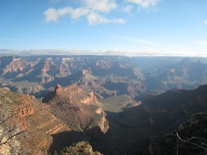
At the center of the image you can see Plateau Point which is our goal.

We left the car just before 8 o’clock in the morning which we thought was early enough but there were already lots of people on the trail. A lot of people had spent the night camping in canyon and were hiking up to the rim in the morning. That is now the plan for our next visit.
It was a little bit odd to walk down first, usually we hike up mountains and once you reached the top you know that it will not take longer to walk back. Here it is more difficult to plan the time since you are not sure of how long it will take you to hike up again.
We thought we kept a fairly good pace down, faster than most people and it turned out to be right. We made it there in 2 h 20 min not 3-4 hours that the description said. At Plateau Point you have a marvelous view of the Colorado river and the canyon. We spent almost 1.5 hours at the lookout, having lunch and enjoying the view. The temperature was now about 15 degrees and very pleasant.
Our lunch spot


The view from Plateau Point

Before noon we thought that it was time to start heading back. We were going to drive back to Phoenix in the evening so we did not want to get back too late. We were able to keep the same pace up as down so we made it back up to the rim in 2 h and 10 min. This was supposed to take 5-8 hours. The fitness program we have been doing the past month seem to have had an effect… We came back up much sooner than we thought so we had time to enjoy the view and the sun some more at the rim before we got into the car and drove back home.

Our first roadtrip in the States – Joshua Tree National Park

Joshua Tree National Park was exactly the change of scenery that we needed. From fancy bars, restaurants and huge yachts to desert, rock and mountains. In two days we did three hikes. All of them were easy, the mountains here are not very high and the trails are easy to walk.

We drove into the park through the southern entrance at Cottonwood Visitor Center. From here we hiked to Lost Palms Oasis which was a very nice hike that featured some cool parts through small canyons, dry river beds and at the end an oasis with palm trees. To reach the oasis you had to walk down a fairly steep canyon. The view was of course much better from the top of the ridge where we stopped for some snacks.

Walking along a ridge to Lost Palms Oasis.

The palm trees at Lost Palms Oasis.

On the way back to the parking lot we climbed Mastodon Peak which was a quite airy peak with lots of boulders you could climb around on. In the background you can see the Salton Sea.

The second day we picked up some breakfast at the local supermarket and drove up to Keys View. The plan was to sit and watch the view while eating. We ended up eating in the car and then went out for 5 min to take some photos. The reason being that it was extremly windy and cold outside. From Keys View you could look towards the south and Palm Springs which is outside the National Park.

At Keys View.

Close to Keys View we hiked the Lost Horse Mine Trail. This is an easy hike which takes you past an old gold mine which is fairly intact. The mine was build in the late 18-hundreds and was in use for almost 4 decades. In total it produced about 280 kg of gold and 450 kg of silver. After visiting the mine we climbed a couple of peaks along the trail which were not really on the map. Just for the fun of it. It was very windy and cold also here so we did not stay for long. At the end the trail seemed to be never ending going through the valleys back to the parking lot. When we came back we had been away for 2-3 hours so it was actually shorter than it seemed.

Joshua Trees.

After a sandwich lunch at Cap Rock (were we found some bolted climbing routes which made us miss our climbing gear) we hiked Ryan Mountain. It was a quite easy hike which did not take more than 30-40 min. This peak is in the center of the western part of the park and from here you have a great view of the whole Joshua Tree National Park.

The view towards north west from Ryan Mountain. On many of the small rocks you can see in the valley there are climbing routes. So next time we will be bringing climbing gear.

On a mini hike in Hidden Valley just before the sun went down. The light was fantastic this time of day. It is at these moments I seriously consider buying an SLR camera.

Joshua Tree is a great place if you like hiking, desert and large boulders. The rock formations you find here are amazing and there are many places to play around among the boulders.

Having fun at White Tank campground.

We found it magical and will be going back. We highly recommend a visit if you have not been here.

Last chance

Winter is definately around the corner. In Sweden we have already seen the first snow. This week we had a snow storm and although it is a few days ago there are still traces of it on the ground. Lucky me then who could go down to Switzerland last weekend and enjoy some warmer weather.

Since the weather was nice we took the opportunity to go on maybe the last hike of the season. Since it is cold and snowy on high altitude we chose Bürgenstock this day. This mountain is only about 1100 meters but beautifully situated at the lake Vierwaldstätter See and famous for its views. This particular mountain does not have a gondola but actually a lift that can take you up the last few hundred meters. This day however it was already closed for the season, not even the café was open. So we did not get our standard beer on the top of the mountain but had to be content with what we had brought along.

On the way we had some serious Sound of Music moments. Like here when we crossed a meadow with this spectacular view.

As we came around the mountain we got this great view of the lake and Lucerne. This side of the mountain is very steep and the footpath is not intended for people that have issues with heights. At some places they have even made tunnels through the rocks. Very nice hike that can be made a little longer if you choose to leave the car close to Stansstad and take the way over Bürgenbergwald.

Autumn hike in Switzerland

This past Saturday we did the Four Lake Hike (Vier Seen Wanderung) between Melchsee Frutt and Engelberg. The SBB (Swiss Railway) has a special ticket for this hike which includes train, bus and cable cars on both ends which makes it quite worth its price. Otherwise the trains and cable cars in Switzerland are very pricey.

In the valleys the fog was thick the entire day but above 1500 meters or so the sky was blue and the sun was shining. The perfect day for an autumn hike on high altitude.
Hiking along the rigde from Bonistock towards Tannensee. Below us on the right side there is a climbing wall with more than 130 routes in all ranges. Actually we came back on Sunday to do some climbing there.
Tannensee.
Having lunch at Engstlensee. This was the lowest point on the hike and after this we had to climb about 400 meters to Jochpass and then down again to reach the cable car on the other side. On Jochpass we did get a well deserved beer before we walked down the last bit. The hike took about 4 hours. With breaks we spent about 6 hours on the track.
All pictures were taken by Michael Wicki who brought us on this hike. Thanks for a great day, Quicky!

Good things about hiking in the Alps

There are several reasons why I like hiking in the Alps. I like rock so the dramatic exposed peaks in the Alps suites me just perfectly. Other good things are that the season is a bit longer (than in Sweden at least) and there are no mosquitoes. Also if you don’t have a lot of time or don’t feel like hiking through the forest on low altitude or have problems with your knees you can in many places take the cable car. This way you can do cool hiking on high altitude even if you just want to do a day hike. But my favourite is that after a steep hike up to a hut somewhere you can always get something cold to drink.

Here, at the Weissmies Hütte in Saastal, we found a sofa where we spent the afternoon with a beer until the guy who worked in the hut came and told us that dinner was served. What a great place!

Via Ferrata (klettersteig) on Jegihorn


The weather made it! It was a beautiful day when we went out to climb the Via Ferrata on Jegihorn in Saastal. We had spent the night in Weissmies Hütte about 1 hour from the start of the Via Ferrata.

The first part of the the route was easy climbing with a few ladders. After an hour or so we reached the ridge. Once on the ridge we had to climb down a little to reach the rope bridge we had to cross to get to the top of Jegihorn.


It was a fairly long rope bridge where you definately had time to think about what could happen if you slipped…


The small dots in the center of the photo are our shadows when we are on the rope bridge.


Immediately after the rope bridge we had to climb up this thing.

After the rope ladder there was a fairly vertical wall we had to climb before reaching the top. They had added some grips to make it easier. This was my favourite part, very exposed and with a fantastic view. Nice!

After about 2 hours on the Via Ferrata we reach the top of Jegihorn on 3206 m. We were hanging around the top for more than an hour talking to other climbers before we headed down to the Weissmies Hütte again for some lunch and a beer. For those who like Via Ferratas I can definately recommend this one, I was climbing it with a smile on my face.