Rockstore is a great climbing and outdoor store located in Lucerne, Switzerland. We would like to thank Rockstore for their support.

has moved to a foreign country
Rockstore is a great climbing and outdoor store located in Lucerne, Switzerland. We would like to thank Rockstore for their support.
In Yosemite National Park we wanted to do a multiday hike. We decided to start it at Tuolumne Meadows. The exact route you can find below. We planned two nights and three hiking days. The first plan was to hike not more than 12 miles or 19.5 km per day. Since we ended up adjusting our route on the way it became 23.6 km the first day, 20.4 km the second and 11 km the third. The reason for the third day being so short was that where we were planning to camp the second night turned out to be mosquito hell. So we kept going until we found a place that was a bit better.
The first day we passed Cathedral Peak and Lakes. It started off uphill, a bit more than we had expected but still ok. Instead of going to the campground at Sunrise we turned off to the east and into the next valley. We hiked along a creek until we found a great place for our first camp.

Before reaching the first camp we filled up our water bottles by the creek. As we were doing this Andy made a joke that now when we were not watching our backpacks, which were 15 m away, a bear would come and get our snacks. Good point I thought, since we had been warned about just this. The bears know our behavior and chooses their moment of attack when we are not paying attention to our stuff. So I went to bring our backpacks closer while Andy was filtering the water. As I brought the second backpack I suddenly saw a bear on the other side of the creek. I think he saw me at the same time I saw him. It was a cute brown little guy, I thought afterwards. My first reaction was to freak out and starting clapping my hands. The poor guy got scared and ran off immediately. Maybe I could have taken a photo or two before scaring him off but I have never seen a wild bear that closely before and there was a bridge just next to us that he could easily cross. So my only photo of our bear sighting is a brown little dot in the middle of the bush. I won’t even bother to show it.

The second day we came by Merced Lake and then headed up towards Vogelsang. After the ranger station at Merced Lake it was steep uphill and got very hot. The wind had been strong ever since we entered the park but now when we wanted it, it was of course gone. This day was probably the most beautiful day featuring granite domes, creeks, water falls and spectacular views of the high Sierras. It was also the hardest one with more than 900 m elevation gain. As we came close to Vogelsang we turned off to the west and wanted to camp a few miles before the Toulumne Pass. After that it should start going downhill towards the Meadows again. Due to about a million mosquitos we ended up camping just at the Pass where it was a bit more reasonable.

The third day was an easy cruise down to Tuolumne again. Basically only downhill and not very steep. But since the first long day had given me some blisters on my feet it was still a pain. (Good thing you never remember these things very clearly afterwards…) I was happy to see the parking lot again where a cold lemon soda and some chips were waiting for us.
More images:
 |
| Tuolumne hike |
Now, after 5 days of hiking and climbing without a shower, we were worth some luxury time at a hotel. 🙂
We have now started the work on translating the blog into German as well. Old posts will not be translated but menus, about and new posts will all be available in German. Just click the little flag in the top menu for the language you want. If there is no flag for German that particular post or page is only available in English.
Enjoy!
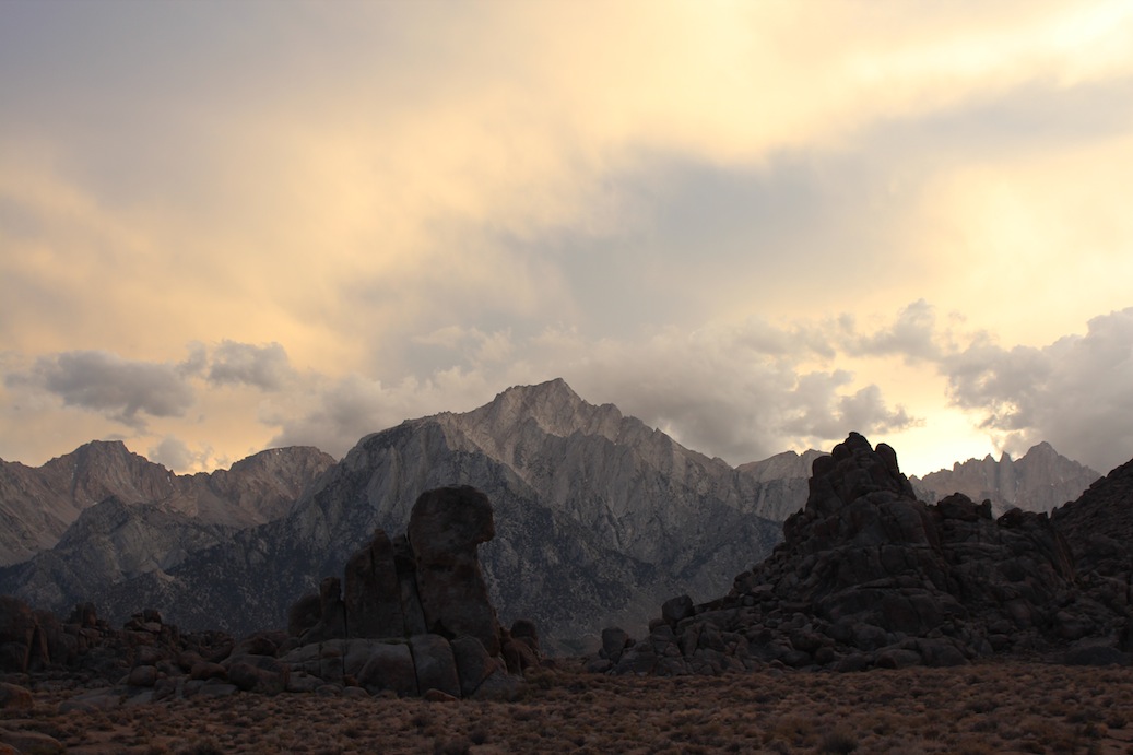
Before we left Las Vegas we bought a climbing guide for some of the higher peaks in the Sierras. The book described a couple of easy routes up Mt Whitney, the highest peak in contiguous America with its 4421 m. We thought that sounded like good fun, to actually climb a higher peak and not only hike it.

As we arrived in Lone Pine, which is the closest town to the trail head, we realized you need a permit to the Mt Whitney area. So we went online and found a one day permit for the next Monday, three days later. Every day there is also a lottery where any cancelled permits are distributed. We were considering trying to get an overnight permit through the lottery. We however decided to go for the one day permit any way in order not having to carry camping gear and climbing gear up half ways up the mountain. We thought climbing gear would be heavy enough. The plan was quite ambitious. In one day we would hike from Whitney Portal up to Iceberg Lake, climb the 11 pitches long East Buttress and then hike down the Mountaineer’s route back to the Portal.

Mt Whithey as we come closer. The East Buttress would be the ridge on the right hand side of the peak.
The night before we drove up to the trail head at Whitney Portal and found a camping spot. We packed all our gear and were all ready to go. We had planned to get up at 3.00 and start hiking at 3.30. But since the neighbors were up already at 2.30 we got up at 2.50 and left at 3.20. We reached the base of the climbing route at 8.30, took a short break and got ready for climbing.

Andy gearing up.

The view from the start of the climb.
According to everything we had read and everyone we had talked to it should be easy to find and easy to climb. The first pitch was easy to find since we had a picture of it in the guide book. However further on it was not so obvious. We had calculated that we had about 30 minutes per pitch but ended up using almost one hour for each of the first two pitches. The wind was hauling and it was very cold. We were after all on 4000 m. My hands were freezing which did not make it easier to climb. Andy also started to get cold and we decided to leave the climbing route, rappel down to the mountaineer’s route and continue to the top using that route.
Any normal person would probably have gone straight down instead of continuing to the peak, but we there to climb a mountain and so we did. With our fairly heavy backpacks we scrambled up the mountaineer’s route. It was not as obvious to find and we lost even more time trying to find the correct way up to the top. Eventually at 14.30 we were on the peak.

Since we did not like the Mountaineer’s route, which was steep and very slippery, we decided to descend using the hiker’s route. This one unfortunately is 11 miles (18 km), one way. The trail was not steep or hard but had an endless amount of switchbacks. 5 hours and 40 minutes later we were finally at the parking lot again. With no energy left we drove to McDonald’s in Lone Pine, ate a quick hamburger and went to bed. Feet, back, shoulders and fingers were hurting at this point and it was a relief to lay down.
Next morning we woke up a bit stiff but surprisingly enough just half a day later we were quite fit again. So now it is time to plan for the next adventure…
Quick facts:
Total 24.5 km round trip
Elevation change 1900 m
17 hours of hiking, climbing and scrambling
10 kg (Angela) resp 15 kg (Andy) backpacks
3 slings and one carabiner left behind (for abseiling)
Telescope Peak is the highest point in Death Valley National Park and hiking it is naturally our choice of activity. Although it is located in Death Valley with its high temperatures it is comfortable to hike in the summer because the peak is at 3366 m above sea level. Actually it is snow covered in the winter so summer would be the best time to go.
The hike starts at Mahogany Flats Campground and is totally 14 miles (23 km) round trip. It climbs steadily during the 7 miles to the peak which makes it a fairly easy hike in that perspective. The trail is nice all the way with a few switchbacks at a couple of places. But it is very long and will take most people a full day. We climbed it in 3 hours, spent about an hour on the top enjoying the view and then went down in a bit more than 2 hours. A suggestion is though to start early because at the start of the hike it is quite warm.

On the way up to the peak, which is the one in the left part of the picture. It is one of those peaks where you never really see the peak itself. You end up passing a number of “false” peaks before you actually make it to the real one. Can be very annoying after a long hike.

On the top which featured an American flag, a register, a first aid kit and a flask of some content we did not dare to taste. 🙂

From the peak looking down the ridge from where we came.
This was a nice warm up hike for what is yet to come…
After leaving Las Vegas we drove to Death Valley. Because it is about 45 C there we did not plan to linger in the valley for very long. It is simply too painful. We arrived late afternoon and drove through the valley only stopping at a view point and at the sand dunes in the center of the National Park. The goal of the day was to drive up as close as possible to Telescope Peak which we wanted to hike the day after.
It was a nice drive in the evening sun, perfect for nice photos. So here are a few.