Warning: call_user_func_array() expects parameter 1 to be a valid callback, class 'collapsArch' does not have a method 'enqueue_scripts' in C:\inetpub\vhosts\globitrotter.com\httpdocs\blog\wp-includes\class-wp-hook.php on line 307

To hike a 14er

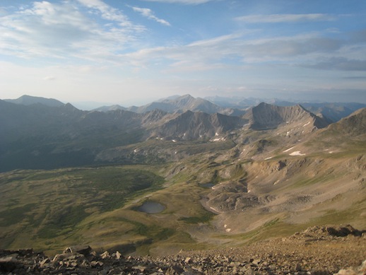
By now we have been on the peak of half of the 55 14ers in Colorado. You might wonder why we have to climb that many. Once you have hiked a few you get hooked and want more. Although they are all about the same height they are all different. The hike itself can be easy walking or partly technical climbing. There are usually several ways up a 14er and we have chosen both easy and harder routes. The harder ones are the favorites since they feature less people and more fun. The view is different on each peak even if they sometimes are very close to each other. Sometimes there are green rolling hills around, sometimes rugged ridges and rock faces. The crowd is always different, you might be alone on the peak or trying to find a spot to sit down among dozens of people.

Below is a photo album from this years adventures in Colorado.

Since there are many thunderstorms in the mountains this time of year it takes some planning to avoid getting stuck on a peak when lightning strikes. According to our experience the clouds starts forming around 10 am and usually the first rain starts somewhere between 12 and 2 pm. We do not like hiking in rain so naturally to avoid it we get up very early in the morning to make it to the top when the sky is still blue and start heading down when we see small fluffy clouds that in no time will transform into dark rain clouds. This means that for a longer hike where more peaks are combined or there is a very long approach we start hiking before 4 am. Just after 5 am it is light enough to hike without a head lamp and usually the first part of the hike is not so difficult to find. Another good thing about starting early is that it is cool and very nice hiking temperature. For easier hikes we might not start until between 6 and 7 am.

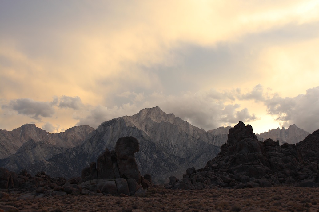
On the trail as the sun is rising. (Mt Bierstadt)

The weather seem to be something that people does not care much about until they are in it. We are usually among the first ones on the trail. Does people not read the weather report? Have they not seen what the weather has been like the past weeks? It is always the same according to our experience. On basically every peak most people will barely make it to the top to get a good look at the view before the clouds roll in. These people will most probably get caught in the rain coming down but will at least be off the peak before the thunderstorms hit. Then there is always the guy we call the 11 o’clock man (or woman). Usually this is one person hiking alone who starts heading up the mountain around 11 am as we are almost down again. He will definitely not make to the top before it starts raining and will have to turn around without even reaching the peak unless he wants to risk getting hit by lightning. This must be very frustrating, going through so much for nothing. We are equally fascinated every time.

It is very obvious which are the popular peaks and not. On a few peaks we have been alone, maybe meeting a few people on the way, and on other there have been crowds. The popular ones are naturally those where you can reach a trailhead with a normal 2wd car and still do not have to hike too far. It is amazing though what people put their 2wd’s through to reach a trailhead. We saw one very sporty car, probably even lower than the original model, on a very obvious 4wd trailhead. He must have damaged his car driving to and from this trailhead. Is it worth it?

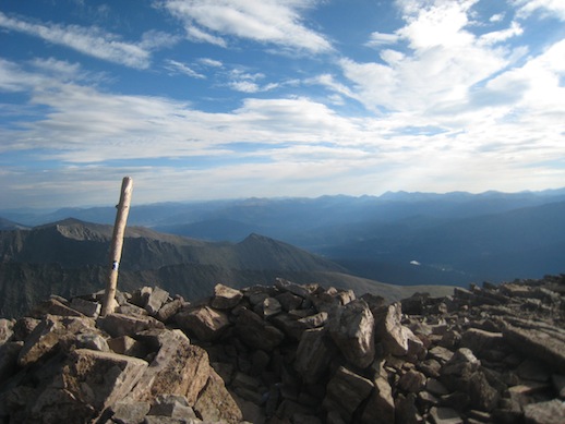
One of the more popular peaks, Grays Peak.

Clothing is another interesting thing. I think it is quite cold on a 14er, the wind is usually strong and the air cold. I could not make it without long pants and long sleeves, usually a windstopper on top of a long sleeved and a short sleeved merino wool shirt. The most Americans though are wearing short (for girls usually very short) pants and often tank tops or t-shirts. My body would scream and refuse to work if I would wear that. I can not possibly hike fast enough to warm my body during these conditions. Maybe on the peak they will put a thin wind jacket on before they hurry down again after taking the obligatory peak photos. It was very obvious as we were hiking Mt Shavano. A lady started just after us and had about the same pace. As the sun came out we stopped to put on sun block on our faces and put on a extra jacket because we were now above the tree line and the temperature had dropped and the wind was chilly. She stopped at the same time, also to put sun block on but she also took her jacket off and zipped off her pants! Does the American bodies work differently or are we just incredibly cold??

The summary is that we can only warmly recommend hiking 14ers in Colorado. It is a beautiful and friendly area with peaks that will fit everybody.


10 14ers in 6 hiking days

It might sound better than it is. We actually did 10 peaks in 9 days of which 3 were resting days and 6 hiking days. That means we did 3 peaks one day, 2 peaks 2 days and 1 peak 3 days. It was our goal to do another 10 14ers this year, like we did last year. However, when we have read our guide book a bit more carefully we found a few peaks that just sound like fun so we decided to aim for another 8 peaks. That will bring us up to a total of 28 peaks and just about half of the 55 14ers in Colorado. I believe we will be content with that for now and have to come back for the rest of them another time.

We believe that we are making a pretty good job climbing these 14ers. Most people that we have talked to hike maybe one or two a year or so. But there are also those who are quite extreme. One guy we have read about did all 55 peaks in 10 days!! He trained for years and had a crew of 6 or so people supporting him during this time. He was also true to the 3000 feet rule which we have not been. This means that for one hike to count you have to climb at least 3000 feet for each peak. We have not done this since some peaks are close to each other and you do not have to loose that much altitude to reach the next peak. We are also willing to use our car in any way to make it easier. Our goal is just to reach all summits at some point. We will probably try and do the rest of the peaksduring a longer holiday in a few years.

So far this year we have hiked Mt Sneffels, Blanca, Ellingwood, Missouri, Oxford, Belford, Huron, Shavano, Tabeguache and Massive.

Mt Sneffels was the easy first peak. We could drive up to over 12000 feet which made it an easy hike.

Blanca and Ellingwood were hard because of the very long approach along a 4×4 road. But the peaks were nice and had some fun scrambling at the end. Also the last part of the hike was nice along a number of lakes.

Missouri, Oxford and Belford were 3 peaks in one day and this was a hard one because of the length and elevation gain. After Missouri we had to drop quite a lot in elevation before we could make it up towards Oxford. It was about as long as Blanca and Ellingwood but even more elevation gain.

The view from Mt Missouri as the sun is rising.

The ridge over to Mt Belford from Mt Oxford.

Mt Huron, which we did the day after, was like a rest day. Short and easy hike, beautiful grassy slopes and a nice view from the top. I would definately recommend this one for a first 14er.

The nice trail up Mt Huron.

Shavano and Tabeguache we climbed together. It was a fairly easy hike but also quite boring. A lot of it was in the forest that seemed endless. Shavano has a pretty cool peak and the hike along its ridge towards Tabeguache was fun. The drive up to the trail head was also very nice.

The sun is rising as we are hiking up Mt Shavano.

On Mt Shavano.

The view towards north from Mt Tabeguache.

Mt Massive was interesting. We chose to climb the south west slopes because we could drive to the trailhead with our car. This way is shorter but steeper than the standard way. This particular day we were happy to have chosen this way because of the traffic on the standard trail. As we reach the top there was a group of about 10 there which left a few minutes after we got there. From the top we could see the standard route and the amount of people coming up. After a little while a teenager reaches the top and says he is the first of a group of about 50 (!) coming up. This was the time to leave and head back down before the rain clouds came in. Mt Massive is the second highest 14er and very close to Leadville which is a popular place to stay. It was obvious how much more popular this peak is although there are so many other peaks in the area.

On our 20th peak, Mt Massive.

Blanca Peak and Ellingwood Point – long and exhausting

Our second 14er attempt was to climb Blanca Peak and Ellingwood Point. These two are just next to each other and therefore easy to do in one day. The problem here is that it is a very long hike to get to the peaks at all. There is a 4×4 road but unfortunately the hardest in Colorado and should only be attempted with heavily modified vehicles. We were able to get up to about 8800 feet with our FJ and therefore having another 5500 feet to climb and a 24 km round trip hike.

Since there are thunderstorms in the afternoon we had to start before 4 am to be sure to make it off the peaks before the clouds come in.

One of the lakes we passed as the sun is slowly rising.

At 9 am we were at the first peak. I was exhausted and was seriously thinking about skipping Ellingwood. But we had met a guy on the way up and we could see how he quite quickly made it over to Ellingwood. The sky was still blue and after some sandwiches and snacks I was happy again. It was not as bad as it looked to hike the ridge over to Ellingwood where we stayed for a little while. We saw some clouds building up and since we knew we had a long way back to the car it was time to leave. At 11 am we left the peak and made it back to the car just after 2 pm just before it started to rain. Good timing!

View from Blanca Peak and the ridge we came up.

Enjoying Ellingwood Point.

Mt Sneffels – short and easy

After a couple of days driving through Nevada and Utah we finally reached Colorado. Here the plan is to hike some 14ers. We drove into one of our favourite places from our trip last year, Ouray. It is called the Switzerland of America, which could be discussed, but ok, close enough. We spent one lazy day in the village. It featured hot springs, beer, coffee/tea and chocolate. At this point we were fairly bored and were looking forward to go hiking.

As the sun rose the next day we headed off towards Mt Sneffels. It was a short hike and not even 3000 feet elevation gain because we were able to drive up to the trailhead with our 4×4. Some would claim this can not be counted as a 14ers since it was less than 3000 feet elevation gain. But we don’t care. We just like the view from the peak and are willing to use our car in any way we can to make it easier. If we were only doing one peak then maybe I would go by the “rules” but right now we have 12 peaks on our list to do in a week so I think we will be doing enough exercise.

We decided to climb Mt Sneffels on the 3rd class rated southwest ridge. This was a good decision since the standard trail was basically just scrambling up a stone field. We took this way down and it did not look like a lot of fun coming up. It took us only 20 min or so to reach the ridge. The climb was easy to find and lots of fun. There was some exposure occasionally which always makes it more interesting.

The view from the ridge as the sun is rising.

We reached the peak already 7.30 am and stayed there for about 2 hours. After 1.5 hours another guy joined us and after 2 hours the masses started to reach the top which meant it was time to leave. From the peak we could see people coming up and there were lots of them. After we left the top they were probably about 30 people up there. This is one reason to start very early, you get the peak for yourselves.

The view from the peak looking down the ridge we came up.

The weather was perfect, warm enough to hang around for a long time and sunny. As we reached the car again some clouds were coming in and we made it back to town just in time for lunch. 🙂

The Mt Whitney experience

Before we left Las Vegas we bought a climbing guide for some of the higher peaks in the Sierras. The book described a couple of easy routes up Mt Whitney, the highest peak in contiguous America with its 4421 m. We thought that sounded like good fun, to actually climb a higher peak and not only hike it.

As we arrived in Lone Pine, which is the closest town to the trail head, we realized you need a permit to the Mt Whitney area. So we went online and found a one day permit for the next Monday, three days later. Every day there is also a lottery where any cancelled permits are distributed. We were considering trying to get an overnight permit through the lottery. We however decided to go for the one day permit any way in order not having to carry camping gear and climbing gear up half ways up the mountain. We thought climbing gear would be heavy enough. The plan was quite ambitious. In one day we would hike from Whitney Portal up to Iceberg Lake, climb the 11 pitches long East Buttress and then hike down the Mountaineer’s route back to the Portal.

Mt Whithey as we come closer. The East Buttress would be the ridge on the right hand side of the peak.

The night before we drove up to the trail head at Whitney Portal and found a camping spot. We packed all our gear and were all ready to go. We had planned to get up at 3.00 and start hiking at 3.30. But since the neighbors were up already at 2.30 we got up at 2.50 and left at 3.20. We reached the base of the climbing route at 8.30, took a short break and got ready for climbing.

Andy gearing up.

The view from the start of the climb.

According to everything we had read and everyone we had talked to it should be easy to find and easy to climb. The first pitch was easy to find since we had a picture of it in the guide book. However further on it was not so obvious. We had calculated that we had about 30 minutes per pitch but ended up using almost one hour for each of the first two pitches. The wind was hauling and it was very cold. We were after all on 4000 m. My hands were freezing which did not make it easier to climb. Andy also started to get cold and we decided to leave the climbing route, rappel down to the mountaineer’s route and continue to the top using that route.

Any normal person would probably have gone straight down instead of continuing to the peak, but we there to climb a mountain and so we did. With our fairly heavy backpacks we scrambled up the mountaineer’s route. It was not as obvious to find and we lost even more time trying to find the correct way up to the top. Eventually at 14.30 we were on the peak.

Since we did not like the Mountaineer’s route, which was steep and very slippery, we decided to descend using the hiker’s route. This one unfortunately is 11 miles (18 km), one way. The trail was not steep or hard but had an endless amount of switchbacks. 5 hours and 40 minutes later we were finally at the parking lot again. With no energy left we drove to McDonald’s in Lone Pine, ate a quick hamburger and went to bed. Feet, back, shoulders and fingers were hurting at this point and it was a relief to lay down.

Next morning we woke up a bit stiff but surprisingly enough just half a day later we were quite fit again. So now it is time to plan for the next adventure…


Quick facts:

Total 24.5 km round trip

Elevation change 1900 m

17 hours of hiking, climbing and scrambling

10 kg (Angela) resp 15 kg (Andy) backpacks

3 slings and one carabiner left behind (for abseiling)


More 14ers

The other day I took out my Colorado’s Fourteeners book and was going to decide if we should bring the book on the trip or send it home first. As I started to read I got an urge to go hiking. Last August we did 10 14ers in 10 days. It was hard but fun and well worth it. Then we did not have much time since we wanted to go to Utah as well during our 4 week vacation. This time around we can spend more time in Colorado and either do more of them or maybe not so many in just a few days.

We started to discuss which peaks to do this year and the more we looked in the book and talked about it the more we wanted to do. Probably we will do at least another 10 this year. I am hoping to do La Blanca, Mt Sneffels and Longs Peak (in Rocky Mountain National Park). The rest we will see as we go along. All depending on weather I guess. Since we are bringing climbing gear this time we might attempt to climb a peak or two. We both like multi pitch climbing and it would add some variation to the hiking. Maybe we will also do a favourite or two from last year. I wouldn’t mind doing Wetterhorn or Handies Peak.

Hiking the valley up to Handies is beautiful with all the pretty flowers.

Conclusion: we are bringing the book.