Warning: call_user_func_array() expects parameter 1 to be a valid callback, class 'collapsArch' does not have a method 'enqueue_scripts' in C:\inetpub\vhosts\globitrotter.com\httpdocs\blog\wp-includes\class-wp-hook.php on line 307

Tongariro Northern Circuit

You might have heard of the Tongariro Crossing, one of the most wellknown day hikes in New Zealand, which is a part of the Tongariro Northern Circuit. The track is about 45 km and we decided to do it in 3 days. The first day was very short, just a few hours to the hut and basically no elevation gain or loss. When we started the weather was a bit unstable but as we woke up the second day the sky was blue.

IMG_3073 copy

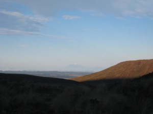
The view from the first hut with Mt Taranaki at the horizon.

From the track we could see the snow capped Mt Taranaki at the west coast. The second day started along the Tongariro Crossing which meant it was full of people. It looked like an ants trail and we were happy it was only a part of our hike that was going to be that crowded. Tourists are generally not very well equipped and on a tight time schedule. This means anything that involves an over night stay without hostels or hotels available will be relatively empty and mainly filled with locals.

IMG_3110 copy

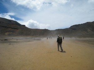
Following the ant trail on the Center Crater.

After an hour or so hiking we found ourselves at the foot of Mt Ngaruhoe (featuring as Mt Doom in the Lord of the Rings trilogy). We had not really planned to climb the peak because we thought there would still be too much snow on the top and that it would be too much for one day. We were going to skip one hut and go to the next one which added a couple of hours to an already full day. But we had seen that the snow had melted and although it was going to be hard we could not resist the temptation.

IMG_3078_a copy

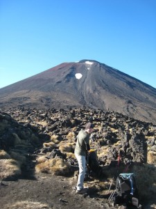
At the base of Mt Ngaruhoe
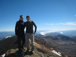
IMG_3089 copy

On the peak.

Mt Ngaruhoe is an active volcano which is an almost perfect cone. It might not look so bad from a distance but it is very difficult to climb with loose rocks and steep slopes. It did not make it easier with the big backpacks but within 1.5 hours we were on the top and could enjoy the views while having lunch. There are quite a lot of people climbing the peak which is dangerous because of falling rocks. The day before we hiked one guy had to be pick up with helicopter after being hit by a rock. We made it though without injuries and could make our way towards the hut.

IMG_3118 copy

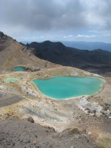
Emerald Lakes which we passed on our second day.

Finally around 6 o’clock in the evening we made it to our hut which was newly opened and had great views of the Mt Ngaruhoe. We just barely made it through dinner before we fell a sleep exhausted after another great hiking day.

IMG_3133_a copy

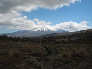
The view of Mt Ruapehu which we saw a lot of the last day. The trail ran between Mt Ruapehu and Mt Ngaruhoe making it a very beautiful part of the track.

The last day was fairly short and easy with not much elevation gain. We made it back in time to have afternoon tea in the Chateau at the end of the track with Anna and Basti that we had met along the way. A very nice ending of a beautiful hike in volcanic surroundings which are not very common in New Zealand. Usually a great part of the hikes are through forest but this one only has about 30 min of forest in three days.

IMG_3161_a copy

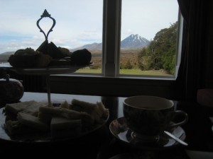
Afternoon tea with a view of Mt Ngaruhoe. What an excellent end of a great hike.

Click the image below and you can see more photos from the hike.

Tongariro Northern Circuit

Lake Waikaremoana – an unexpected journey

The Lake Waikaremoana track is actually one of the New Zealand so called Great Walks but not very well known. Hardly any tourists know about it, including us until recently. We were told about this track by an Israeli tourist we met in Holly Hut on our Taranaki adventure. It sounded nice and after doing some research we booked huts and were on our way.

IMG_3014_a copy

View over Lake Waikaremoana.

We spent one night before the hike at the campground by the lake that also operates the water taxi you need to take to the start and from the finish of the track. It was nice to get a boat ride on the lake but the down side with the water taxi is that you have to be somewhere at a certain time which is difficult when you have not done the track before. Afraid of not having enough time you instead end up waiting for a long time. We had nice weather though so it was not so bad lingering at the end of the track. We were also in the good company of Warren who did the same hike as us. He was nice enough to then invite us to his home in Palmerston North were we later spent a few nice days. We particularly liked to try Pavlova, the national New Zealand dessert, and Shepherd’s Pie. 🙂

IMG_3006_a copy

On the ridge about halfways to Panekiri Hut.

The first day we hiked up and along a ridge line to Panekiri Hut. It was a short walk, although including some elevation gain, and we were at the hut early in the afternoon. At the hut we met a school group from Orewa and ended up playing games with them a few hours. It made the time pass a bit quicker and we learned some new games we will probably never play again or remember for that matter. 🙂 The views from the top of the ridge were great and different from what we were going to see the coming two days.

Day two the trail took us off the ridge and down to the lake. The trail more or less then followed the side of the lake until the finish of the track. We made a small side trip to a waterfall which was actually one of the nicer ones we have seen so far. Even with this side trip we had some time to relax by the lake for a while. Our hut was hidden behind a small hill which at the end of the day felt like a mountain. Overall there had been more ups and downs than we had expected on this day. It felt good to be at the hut and be able to wash (we did not swim, it was way too cold for that) a bit in the lake. Warren was already there to welcome us and the three of us were the only ones in the hut that night.

IMG_3033_a copy

The waterfall

IMG_3040_a copy

Relaxing

The last day we started early to make sure we would be at the pick up point in time. It was an easy tramp to the end of the trail. We did pass one hill but it was not very steep and actually easier than we had expected.

IMG_3047_a copy

Leaving the second hut.

Even though we took our time and made several breaks along the way we were still one and a half hours too early. Overall, it was not a very strenuous hike but our feet were stilltired and we were happy to be on our way to Taupo and a shower.

IMG_3055 copy

Leaving the pick up point at the end of the track.

Want to see more photos? Click on the image:

Lake Waikaremoana